
Dr. John W. (Jack) Glendening
30 April 2002 Copyright 2002
| Ten reasons to use a BLIPMAP |
| Easily interpreted, requiring little meteorological background |
| Relevant predictions, what a soaring pilot really wants to know |
| Supplies information not available on meteorological weather sites |
| Quickly evaluated using its graphical presentation map |
| Covers an entire region, including elevated terrain |
| Has been verified by actual pilot experience |
| Available on the evening prior to the flight |
| Uses the latest meteorological observations, updated through the night |
| To anticipate route legs having more difficult conditions and how the soaring day will begin and end |
| To avoid missing a great soaring day |
Yet these have significant limitations: they only indicate conditions at a single location, they don't provide many of the parameters that a soaring pilot needs, and they still require some investment of time. These limitations matter to the cross-country pilot, who is interested in conditions over a wide area. He might wish to make sounding analyses at multiple locations corresponding to possible routes, but this is usually not practical. Furthermore, many sounding analyses are tied to specific sounding locations associated with airports, whereas the conditions of most interest may be far from an airport or in elevated terrain, at locations where the atmosphere differs significantly.
This article briefly describes a solution to these forecast
limitations: using a computer to automatically analyze soundings
over a wide region and calculating soaring prediction parameters which
are displayed in a graphical format, akin to the weather maps familiar
to TV watchers, and accessed via the Internet. I call this
product a "BLIPMAP", for "Boundary Layer Information Prediction MAP"
(there is a separate product called a BLIPSPOT focusing on individual
locations). Here "Boundary Layer", abbreviated as "BL", refers
to the scientific description for the turbulent atmospheric region
mixed by thermals - so a climb to the top of a thermal nearly reaches
the top of the BL, although the glider's sink
rate does not allow a climb to the actual thermal top. BLIPMAP
predictions are currently available for all regions of the US.
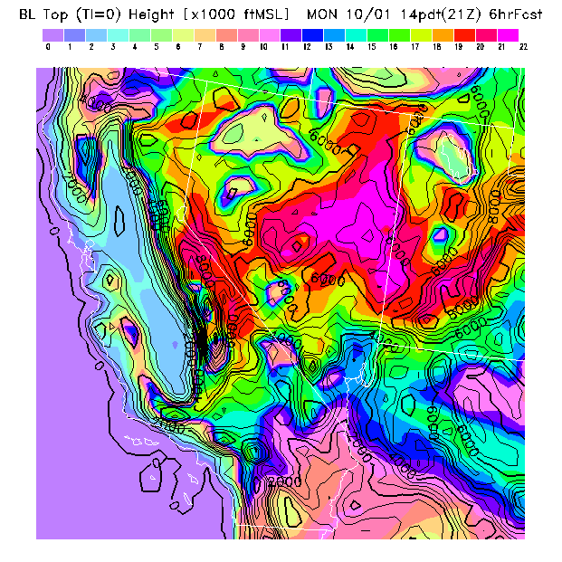
Since thermals create the BL, the thermal tops correspond to the "BL Top" and BLIPMAPs provide that parameter as a guide to the maximum thermalling altitude. Over flat terrain the actual height reached by the glider will be somewhat lower, depending upon glider performance and pilot proficiency - but over complex terrain local small-scale topographic variations that are smoothed out of the model terrain grid can produce glider altitudes equaling the BLIPMAP predictions. Fig.1 illustrates a BLIPMAP "BL Top" prediction at 21Z, or 1 PM local time, near the time of peak thermal activity. The colors correspond to heights given in the color bar while black contours indicate the smoothed terrain elevations used by the model.
Most apparent is that higher thermalling altitudes are
found at higher terrain heights. Of course one doesn't need a
fancy weather prediction model to expect that relationship, but the
model does provide specific predictions in elevated terrain and daily
inspection of the BLIPMAPs reveals day-to-day changes and shifts in
the locations of the highest thermalling heights. For example,
on this day thermalling altitudes in the coastal mountains north of
San Francisco were predicted to be higher than those in the coastal
mountains south of San Francisco - this is typically the case since
elevations are lower in the southern range, but nevertheless on some
days the higher predicted thermalling altitudes will be in the
southern mountains.
|
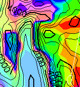
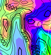
Fig.1's date was chosen because conditions were then unusually strong
for October, allowing two pilots to make record-setting flights from
the coastal mountains west of California's Central Valley, north of
San Francisco, to Minden Nevada, just east of Lake Tahoe
at the knee of Nevada's western boundary. A close-up of this
region (Fig.2) and this can be compared to conditions
predicted for the previous day (Fig.3), a day more
typical of the fall season. On October 1 thermal tops were about
5000 ft higher in the elevated terrain along which the flights
occurred than on the previous day. Conditions in the Central Valley itself were relatively
weak on both days, with a maximum thermal
height of roughly 3000 ft, and since flight altitudes were above that
height, crossing the Central Valley required a long traversing
glide. These figures exemplify BLIPMAP's ability to make
predictions at different locations, since conditions in the mountains
differed greatly between the two days but conditions in the valley did
not.
| Fig.2: Details of "BL Top" BLIPMAP for October 1 | Fig.3: Details of "BL Top" BLIPMAP for September 30 |
|---|---|
|
|
Predicting rate of climb is more complex, and here BLIPMAP
provides what other sounding analyses cannot.
While empirically-obtained expressions exist which attempt to predict
climb rate from a temperature sounding, their accuracy is
greatly limited by the fact that they do not explicitly depend upon
the physical mechanisms that actually drive the thermals.
Thermal strength fundamentally depends upon two factors: the
rate at which heat flows into the atmosphere from the ground
and the depth of the BL. The importance of the former
should be intuitively clear - if the ground heats more, then
thermals will tend to be stronger. The BL depth is important
because a thermal bubble accelerating vertically will reach a higher
velocity if it can accelerate for a longer time. A well-established
theoretical formula relates these factors to thermal updraft strength
and BLIPMAPs employ this formula for their prediction of W*, or "W
star", the scientific abbreviation for the convective updraft scale
which here represents the predicted average thermal vertical velocity
at mid-BL. To estimate the glider climb rate, its sink rate must
be subtracted from W*. It is gratifying to my sense of
scientific correctness to find, based on pilot reports, that W*
provides realistic predictions of glider climb rates without any need
for empiricism. This prediction is possible because surface
heating is predicted by the model, but this heating is not available
from traditional sounding analyses so they cannot predict W*.
|
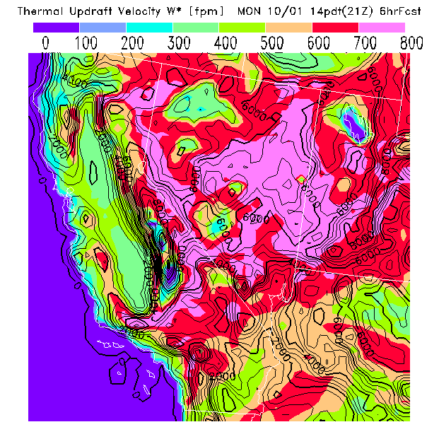
Fig.4 illustrates the W* predictions corresponding to the height
predictions in Fig.1. Strong updrafts were predicted over the
elevated slopes on both sides of the northern Central Valley, along
the "record setting" route - much stronger than
for the previous day. Looking elsewhere, one can see why
soaring conditions in Nevada's Great Basin are legendary: large
updrafts are generally predicted over that region, with local clouds
being responsible for a patch of low updraft velocities between Reno
and Las Vegas and for a swath across southern California and northern
Arizona (also, soaring over Utah's Great Salt Lake is not very
promising!).
While the above parameters are those most often useful when predicting thermal lift, additional factors should often be considered. As one example, if winds are strong then thermals can be torn apart by wind shear even when surface heating is strong. BLIPMAPs provide an estimate of this effect by calculating a Buoyancy/Shear ratio, the wind shear effect being significant when this "B/S ratio" is 5 or less. Since this depends upon the surface heating, it also is not predictable from a traditional sounding analysis. The B/S ratio can often be neglected when making soaring forecasts since wind shear is often not a major factor - but ignoring it will lead to an incorrect forecast on those days when wind shear is a factor.
All pilots know that thermal soaring is greatly affected by the presence or absence of clouds, but predictions are difficult because the effects are are not straightforward. Clouds can improve thermal soaring, since their release of latent heat adds to the buoyancy aloft, but clouds can also limit thermal soaring through imposition of a cloud base below the thermal tops or by decreasing solar heating of the ground. In addition, models find humidity difficult to accurately predict, so any cloud predictions will have much uncertainty. Nevertheless the BLIPMAP program does attempt some BL cloud predictions, the more successful of which are its predictions of overdevelopment and of thunderstorm development. More problematic is its prediction of smaller clouds, such as puffy BL cumulus or thin cloud layers aloft - this is a present forecast weakness.
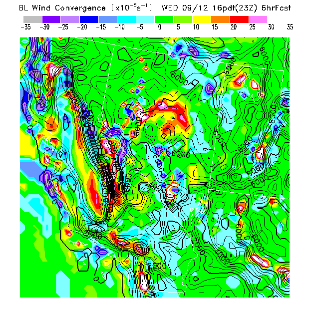
I will mention one final prediction because it
provides something not usually forecast - the BL wind
convergence. Convergence is created by horizontal differences in
wind speed which, since air cannot be greatly compressed, sqeezes
air upward. Pilots often refer to this phenomenon as a "shear
line" which is permissible if one realizes this refers to
horizontal wind shear but can be misleading to the unawary
since generally "wind shear" refers to a vertical variation in
wind speed and/or direction. While this parameter's accuracy is
limited by the model's coarse resolution of convergence features, pilot
reports indicate that convergence predictions often do correspond to
convergence lines that form in the northern end of California's
Central Valley and can be utilized for lift, being particularly useful
at the end of the day when thermal lift has died off. While the
observed locations are often not precisely as predicted, since the
actual lines are very small-scale, the existence of such lines in
predictions is correlated to their actually being found in the
air.
|
Fig.5 illustrates strong convergence predicted at the northwest
corner of California's Central Valley (depicted in white). It
also predicts a north-south convergence line near the center of the
southern Central Valley (in red), a line which initially formed over
the mountains to the west and moved eastward. Many pilots are
not accustomed to using convergence features, but having predictions
may help pilots look for them. However, such predictions can be
"noisy" so must be viewed with caution - they are much more reliable
when consistently found over several consecutive prediction times.
The model predictions must be
post-processed to provide parameters specifically of interest to
soaring pilots. A computer downloads the data
for the entire US, selects regions of interest, computes the
parameters, creates the maps, and posts them on the "drjack"
website. These computations are initiated the evening before
and, if data is available, the first BLIPMAP is posted to the website
prior to 0130Z, with updates being provided through the night.
For the CA-NV region predictions for multiple forecast times are
available, which have been found useful in indicating when the thermal
day will begin and how it will end. Convergence features, for
example, often occur in the later afternoon hours.
The ability to post-process high-resolution model output provides opportunities to forecast conditions which produce good soaring but are often overlooked. For example, the convergence predictions illustrate how non-thermal phenomena can be forecast. Other possibilities also exist. For example, it might be possible to make cross-country ridge soaring forecasts by determining a small-scale ridge height and orientation for each 20 km grid box and then computing the perpendicular wind component at the ridge height over the model grid.
At present, BLIPMAP forecasts are available only for a single day
since the GSD RAP model does not produce longer term forecasts.
Yet computer power progressively increases and just recently
forecasts with twice the resolution of the RAP BLIPMAPs have
became available from the National Weather Service's ETA model on an
experimental basis. These forecasts extend out to 84 hours,
although they are not updated as frequently as are the GSD RAP
forecasts, and could potentially provide BLIPMAP forecats up to 3 days
in advance! However, a practical barrier to using this data for
improved predictions is that very large bandwidth is needed to
transfer the half-gigabyte model output files to a local computer for
the required post-processing, since the costs involved are
significant.
The automated BLIPMAP performs the rote work required for a soaring forecast and provides numbers which are meant to be immediately useful to soaring pilots. But still better forecasts are possible when pilots use their own knowledge, intelligence, and previous experience to evaluate these predictions and create a "value added" interpreted forecast, particularly when model weaknesses are taken into account.
BLIPMAP predictions are intended to provide thermal soaring predictions not available elsewhere. BLIPMAPs do not indicate when non-thermal soaring conditions such as wave or ridge lift occur. Predictions of other, more traditional, meteorological factors which affect soaring conditions, such as precipitation, will need to be obtained from other sources, such as the GSD RAP forecast product webpage.
In addition to the BLIPMAPs I also produce a daily thermal soaring forecast product designed for individual locations called the Thermal Index Prediction (TIP). Being the first soaring prediction product I created, TIPs are based upon more traditional sounding analysis techniques, though extended by utilizing an estimate of the surface heating. I consider BLIPMAPs to be more accurate, but TIPs remain useful because they provide advance predictions, of up to two days from the current day, which BLIPMAPs do not. Although TIPs can be used by pilots to evaluate soaring conditions expected for the current day at an individual location, I believe they best serve as an "early warning" of future conditions and that current day prognostication is best accomplished by examining either the BLIPMAPs or their companion product called BLIPSPOTs, which provide BLIPMAP forecast parameters in text format at hourly intervals for individual locations.
BLIPMAPs are continuing to evolve and GSD forecast availability is
subject to change, so it is possible that the BLIPMAPs available at
the time of your reading this differ slightly from what
is described above. Reading the provided website documentation will
hopefully resolve any questions.
|
Web Links
Kevin Ford's Thermal Index Report Generator: http://www.soarforecast.com GSD RAP interactive soundings: http://www-frd.fsl.noaa.gov/mab/soundings/java/ GSD RAP forecast products: http://maps.fsl.noaa.gov/pig.cgi?20km_MAPS DrJack's Thermal Index Prediction (TIP): http://www.drjack.net/TIP/ DrJack's BLIPMAPs: http://www.drjack.net/BLIPMAP/ DrJack's BLIPSPOTs: http://www.drjack.net/BLIPSPOT/ |